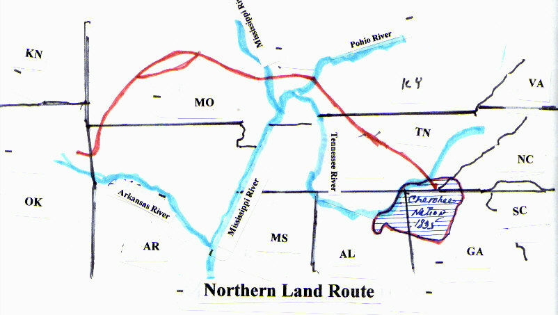
Return Navigation Page Return Elias White Return History Page Return Resource Page
The Arrival from SC Other Migration Trails

Trammel's Trace 'The Road to Texas' - See MAP below

Trammels Trace Trammels Trace Map Texas County Formation Maps
Very Large Maps Area's of Interest
Warning:  Need fast computer!
Also see "The Arrival" for Those on the White Wagon Trains of 1846 & 1847
Trammel's Trace

     After the Louisiana Purchase in 1803, Americans from Tennessee, Kentucky, and Missouri moved down the Southwest Trail into Arkansas in search of land and opportunity. Crossing Arkansas diagonally from northeast to southwest, the Southwest Trail ended in U.S. territory at the Great Bend of the Red River, where Fulton (Hempstead County) was later founded. From that river crossing, Trammel’s Trace emerged as the first
road from Arkansas into Texas from the north, terminating at the El Camino Real in Nacogdoches.

     Named after Arkansas trader and horse smuggler Nicholas Trammell Jr., the route was a former Indian path that was adopted for smuggling horses as early as 1813. (The spelling of the name of the Trace with one “l” mirrors its most common appearance on the maps of the General Land Office.) As the first Anglo-Americans began to move into Spanish Texas, Trammel’s Trace from the north and El Camino Real (the Old San Antonio Road) from the east were the only routes into the territory.

     Nicholas Trammell moved to the White River in Missouri Territory as early as 1807 to establish his trading activities. He moved to Pecan Point, in present-day Red River County, Texas, around 1818 and then followed the migration into Texas around 1822. He acquired a league of land at the Trinity River crossing of El Camino Real but, in 1826, was chased out of Texas as a result of land disputes in an incident that sparked the Fredonian Rebellion. He first used the trail that bears his name to smuggle horses through the Neutral Ground to Nacogdoches and then east across the Sabine River to the United States. Rather than capturing horses from the herds of wild mustangs that roamed the region, Trammell likely acquired them through illicit trade with Native Americans who captured or stole them from settlers and other tribes. Trammell was accused at various times of murder, plunder, and thievery, but much of the information surrounding him is myth and legend. What is documented is his long history as a trader, opportunist, and seeker of the challenge and reward of racing horses.

     When waves of migration into Texas began after 1821, Trammel’s Trace became one of the primary routes to the colonies. Early Hempstead County records document the development of ferry services at Fulton and at Dooley’s Ferry farther down the Red River used for carrying immigrants from Arkansas into Mexican Texas. After the Texas Revolution in 1836, more direct roadways between established settlements began to replace the winding track. Even though Trammel’s Trace was little used at that time, Trammell guided troops down the trail from Washington (Hempstead County) during the Mexican War in 1846. Leaving Arkansas, the trail crossed present-day Hempstead and Miller counties. Some evidence of the old road still exists, but its path is largely lost to history due to land development.

      In the 1940s, James and Mary Dawson researched the old road, and their research is being continued with more modern mapping tools. The Dawson collection can be found at the Southwest Arkansas Regional Archives at Old Washington Historic State Park.

Also see "The Arrival" for Those on the White Wagon Trains of 1846 & 1847

 TOP

MAP OF TRAMMEL'S TRACE

Also see "The Arrival" for Those on the White Wagon Trains of 1846 & 1847

TOP

Link to more information and Trammel Trace Project

http://www.trammelstrace.org/Index_files/frame.htm#slide0010.htm


TOP

MAPS AND MIGRATION TRAILS
Some Possible Routes
Others from South Carolina took the same path


A general map of routes below from South Carolina

Some folks who left SC, west, went up into NC and
turned west onto trails that led through the Cumberland
Gap, a well travelled portal of major migrations to the west
then down a bit thru KY to Eastern TN and up the Mississippi
River to St Louis, and from there they could go further west or turn
south, as our folks probably did, down Tammel's Trace to Bowie Co TX


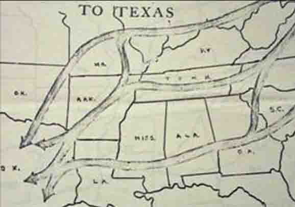
Many South Carolina folks took the same route as most Cheorkee's did during
their removal from GA and TN; Eastern TN, up the Mississippi River to St Louis MO,
and then at that point, I believe, our folks left that trail, turned southwest down Trammel's Trace
through MO, AR, |and East Texas, Texarkana area was right on Trammel's trace, and as we know, Ben
and Polly, and her mother settled Texarkana AR and Texarkana TX, at least on their initial arrival.  Other's
came with them and others preceded them to the Bowie county from SC and many followed this migration west.

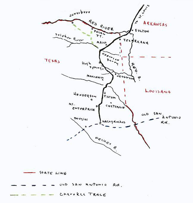
Closer map, upper left coming from St Louis and down into East Texas

Ben and Polly and her mother at first settled in Texarkana TX, at this time
they were the first to physically settle this area, Sarah Nix, Polly's mother is
recorded as the 1st settler in Texarkana AR, was in Texas until they re-did the
border between TX & AR. Ben and Polly was considered by many to be the 1st
to settle Texarkana TX, though the land was owned by Moores, I believe, they did
not live on that land at the time, Ben and Polly bought lands from the Moores and then
 built their homes and farms on that property, thus receiving credit as the 1st settlers here

Note:
Stephen White, Elias's brother arrived in East Texas Jan 1836
in an area they had called Mustang Prairie, later Houston County,
not to be confused with Houston the city, as it was in Harris Co.
Stephen lived in or near the town of Randolph in Houston Co.

The Original Houston County was sliced off Nacogdoches County,
the Mission was included, Trammel's trace, would now come
right into Old Houston County Texas, later split into smaller counties.

Houston Co TX was said to have been the original destination of
Elias's party, to join up with his brother Stephen White, however,
the family liked Bowie Co TX, and remained, at that place.

In 1850, Lewis Bobo, who had come with Elias's wagon train from
SC, he the son of Elizabeth White Bobo, sister to Elias.  He ended
in the Crockett area of Houston Co TX, Stephen White was east of
this town.   Lewis had lived with Sarah Nix's family, in Texarkana AR
she the mother in law of Ben White, son of Elias.  Lewis left in 1850
and moved down to Houston County, probably for opportunity.

Lewis Bobo would have taken Tammels Trace down to Houston Co.
as he lived right off that trail in Bowie County TX.  Lewis Married
there and had children, died in the Civil War that ended his journey.

Stephen White I suspect used Old San Antonio Road, coming from the
east, as it passed right through Nacodoches and Old Houston Counties.

 TOP

Texas County Formation Maps 1836 - 1880
 

1836 Over lay with current counties

1840 Over lay with current counties


1850 Over Lay with current counties


1860 Over lay with current counties

1870 Over lay with current counties

1880 Over lay with current counties

TOP

 Return Navigation Page Return Elias White Return History Page Return Resource Page

mike3113@white-family.com